

|
Peter Loud |
|
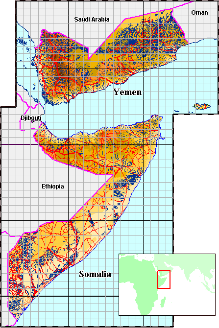
Hi Guys, Yemen and Somalia have been receiving some attention in the months since 9/11, so here are a few maps that I've developed, they still need lots more work. (If you are a commercial organisation you could buy the fully detailed GIS). I am unfamiliar with the status of Somaliland and it's relationship with Somalia. My maps are concerned with the geographic details and do not imply anything about the political status of Somalia/Somaliland. The colours that I normally use for contour polygons are chosen to suit lush, wet South East Asia and don't look right for dry barren Yemen. I have temporarily introduced a new set of contour colours which I thought might better represent this area. I haven't prepared a legend yet. To my surprise, North Somalia has some lush forested hills, so my contour colouring is misleading. It looks an interesting place for the adventurous traveller :-) The map data for Somalia has quite a few errors and omissions. Contour polygons are a problem, especially with North Somalia. There are many errors in the original elevation data which makes it very difficult to convert contour-lines to polygons. There are also missing 'inland waters'. The roads, in the orginal database, which came from the US military, for the southern half of Somalia have been corrupted. |
|
These maps have been developed from the |
|
It's a pity these are just screen dumps of around 800 x 1000 pixels, when
they are done full size all the detail comes out,
they are fantastic, (but that's commercial and costs money ;-(
Somalia Somalia, with District Capital |
 |
Copyright Peter Loud 1997 - 2006
No part of these Web pages
may be reproduced without written permission from Peter Loud,
but you are welcome to create a link, from your web pages, to:
"Maps of Yemen and Somalia by Peter Loud",
www.peterloud.co.uk/yemen_somalia/

|
For further information contact Peter Loud 
|
Total hits for Pete Loud's Websites Total Hits: |